uGridd Adds Railroad Grade Crossing Federal Accident and Inventory Reports
The uGridd Corporation has expanded its cloud infrastructure depository to provide United States public and private railroad grade crossing data including the federal accident and inventory reports. Drawing from hundreds of open infrastructure databases, uGridd centralizes the data in its depository and makes it available for free to the general public simply by registering at uGRIDD.com.
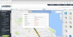
The depository is tied to an internet map. Accessing the data for a particular geographic area is easily accomplished by choosing the uGridd Location of Interest (LOI) tool button located on the map webpage, designating the desired search radius and clicking a point anywhere in the United States. (Line and shape drawing options are available as well.) With lightning speed, all of the data layers will appear left of the map.
By clicking the railroad crossing layer, an icon for every crossing in the search radius will appear. By clicking on the desired crossing icon, a menu will show providing the crossing ID, Railroad Owner, Division, Subdivision, Street, Milepost, and links to Inventory + History Report, Accident Report, and Contact sheet. By clicking on the button users can access related metadata. The data is drawn from the Federal Railroad Administrations publicly accessible railroad crossing data.
