DART to expand use of real-time data to better track vehicle locations, delays and service changes
The Dallas Area Rapid Transit (DART) will expand the use of real-time data so more customers can track vehicle locations, delays and service changes as they happen.
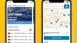
The new initiative allows customers to be able to access key information on Google Maps, the Transit app and various other apps. The information was previously only available on the GoPass app and DART’s website, by text or on kiosks and transit center digital dashboards.
“One of our strategic goals is for more people to use and rely on DART because its services are attractive and convenient,” said Dr. Julius Smith, DART vice president and chief information officer. “To do that, we will continue to do all we can to deliver information directly to our riders in new and expanded ways. Our hope is for riders to be better able to plan their journeys, reducing uncertainty and minimizing wait times.”
DART Board members pushed for the expansion so more riders will have easier access to real-time vehicle locations, arrival time predictions and alerts such as detours and cancellations.
DART light- rail and bus ridership have continued to grow so far this year compared to prior years. The agency and its employees are also putting extra emphasis on safety, cleanliness and reliability.
“We’re grateful to have begun this relationship with DART and we can’t wait for Dallas riders to benefit from this reliable data – which can be seen by the thousands of people already using Transit, as well as those who rely on other apps or websites,” said David Block-Schachter, chief business officer at Transit.
System leaders hope the shared data also fosters a growing culture of collaboration between DART, app developers and the wider community.