Public transit riders help one another avoid crowds with the Transit app
Transit app has rolled out a new in-app feature that gives riders crowding information.
In some cities, Transit says solving crowding information was relatively straightforward since vehicles have real-time crowd counters already installed, allowing Transit to obtain the data, convert it into a readable format and publish it in the app.
But Transit says most cities were not like that. Consider New York — where only some of the Metropolitan Transportation Authority’s fleet have crowd counters installed. Or other agencies like Los Angeles County Metropolitan Transportation Authority (L.A. Metro), which do have crowd counters, but collect the data from the machines days later — making “real-time” a moot point.
To solve this problem, Transit built a prediction engine in partnership with L.A. Metro. It creates real-time crowding estimates, using historical crowding levels.
Transit says it has found that crowding predictions are 88 percent as accurate as real-time crowd counters.
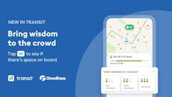
But what if there isn’t any data to make predictions from? Hello, GO crowdsourcing. Transit is adding the last missing piece to the jigsaw with GO crowdsourcing. Riders can now self-report crowding levels within Transit.
In cities without real-time crowd counters (or where only SOME of the fleet has crowd counters), riders will see crowding reports filed in the past 10 minutes by riders upstream so they know the crowding level before the bus pulls up.
Transit has launched this feature alongside 35 of its official transit agency partners, with more cities on the way.
This is an evolution of GO, a crowdsourced “Waze-like” feature that gives riders step-by-step directions. As riders progress along their route, they are constantly updating their location. Riders choose to share this information with other riders, thereby improving the precision of bus and train locations. With GO, real-time location data gets shared by riders onboard, whose phones can update vehicle locations faster than bus/train transponders.
Now it’s time for GO’s second act. When riders tap GO, they will not only provide more accurate bus and train locations to riders waiting downstream but they’ll also be able to tip them off about crowding by answering a one-tap survey when they board to report the vehicle’s crowding level. When a nearby rider looks at a trip that involves that bus or train, they’ll see the crowding report.
Transit says early results show this can work: More than half the people who see the “how crowded is your ride?” survey ended up answering it. Agencies are doing their part, too, letting their riders know via social media they can tell other riders know if there’s room before they board.
Helping crowds count crowds
By working with agency partners, Transit has been able to deploy a powerful and free way to measure crowds, especially for agencies that don’t yet have the budget for $8,000-per-vehicle automated passenger counters.
And by harnessing the power of GO, Transit has given riders the ability to create crowding data where it doesn’t exist. It’s the next obvious step (after enforced mask policies) to give riders a sense of security — knowing that, if their intended ride is too busy, a non-crowded option is only a few minutes away.