Google Maps adding pandemic-critical information for commuters
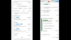
Google Maps has rolled out an update that incorporates features to help users as they plan to drive or take public transit through various stages of civic reopenings. Travel times, COVID-19 restrictions and crowd levels will be visible for a given route.
The United States is among the first round of countries, which also include Argentina, Australia, Belgium, Brazil, Colombia, France, India, Mexico, Netherlands, Spain, Thailand and United Kingdom, where relevant alerts from local transit agencies will be shown for those routes affected by COVID-19 restrictions, such as if government mandates impact transit services or require a rider to wear a mask on public transportation.
Google Maps is also making it easier for people to contribute crowdedness information for lines, building on a feature it introduced last year to tap crowded-sourced information to predict how crowded public transit will be. Google says this information is available by looking up directions, tapping through to see the Transit Details, then scrolling down to find crowdedness predictions (where available), where a rider can contribute his or her own experiences.
A new feature to support social distancing allows a rider to see the times when a transit station is historically more or less busy to plan a trip accordingly. A user is also able to look at live data showing how busy a station is currently compared to its usual level of activity. Google says these capabilities are powered by aggregated and anonymized data from users who have opted-in to Google Location History, a Google account-level setting that is off by default. Additionally, Google notes the insights gained by this setting only surface when the company has sufficient data to meet privacy thresholds.
In February, the company announced new insights that would be included from other riders such as temperature of a vehicle or trains, accessibility and security onboard, as well as designated women’s sections in regions where transit systems have them.
“These insights are now rolled out globally, helping you find feedback from past riders when available and submit your own, right alongside public transit routes,” said Ramesh Nagarajan, product management director, Google Maps. “To help wheelchair users around the world know before they go, we’ve added more granular accessibility information for people to find and contribute, including where there are wheelchair accessible doors, seating, stop buttons and more.”
Google Maps says it is actively working with other agencies around the world to bring more data to users.
About the Author

Mischa Wanek-Libman
Group Editorial Director
Mischa Wanek-Libman is director of communications with Transdev North America. She has more than 20 years of experience working in the transportation industry covering construction projects, engineering challenges, transit and rail operations and best practices.
Wanek-Libman has held top editorial positions at freight rail and public transportation business-to-business publications including as editor-in-chief and editorial director of Mass Transit from 2018-2024. She has been recognized for editorial excellence through her individual work, as well as for collaborative content.
She is an active member of the American Public Transportation Association's Marketing and Communications Committee and served 14 years as a Board Observer on the National Railroad Construction and Maintenance Association (NRC) Board of Directors.
She is a graduate of Drake University in Des Moines, Iowa, where she earned a Bachelor of Arts degree in Journalism and Mass Communication.