Is your bus late? How crowded is it? Google knows and now, you do too
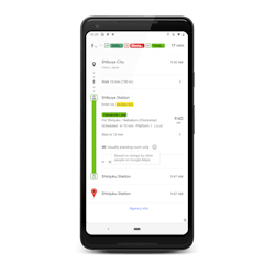
Google has included two updates to the transit information displayed in Google Maps that will now be able to forecast bus delays and predict how crowded a bus or train will be. The company says the Google Maps features will help users "better plan for your transit ride and stay more comfortable along the way."
Google Maps live traffic delays will inform riders if a bus will be late, how long the delay will be and provide more accurate travel times based on live traffic conditions. The feature will be provided to cities where real-time information is not provided directly by local transit agencies.
"As the world's cities continue growing, commuters want to know when to expect delays, especially for bus rides, which are prone to getting held up by traffic. While public transit directions provided by Google Maps are informed by many transit agencies that provide real-time data, there are many agencies that can’t provide them due to technical and resource constraints," wrote Alex Fabrikant, research scientist, Google Research, in a June 27 blog post.
The live traffic delays tool is driven by a machine learning model to better predict how long a given bus trip will take by combining real-time car traffic forecast with data on bus routes and stops. The feature first launched within 10 cities in India at the beginning of June.
Fabrikant provides more detail about how the Google model was built and works and what is being done to improve upon it in his blog, which can be read here.
The second feature being incorporated into Google Maps will predict how crowded a given mode of transit will be and allow riders to decide to squeeze in or wait.
"We’re introducing transit crowdedness predictions so you can see how crowded your bus, train or subway is likely to be based on past rides. Now you can make an informed decision about whether or not you want to squeeze on, or wait a few more minutes for a vehicle where you’re more likely to snag a seat," explained Google.
The information Google Maps provides through the crowdedness predictions is based on optional feedback provided by users of Google Maps. Google says it analyzed, aggregated and anonymized reports of crowdedness from Google Maps users during peak commuting hours between October 2018 and June 2019 to learn how transit crowdedness varies across the globe.
Google's evaluation ranked the world's most crowded transit lines, including subways, metros, commuter rails and other heavy transit and found Brazil had six of the most crowded lines, Tokyo, Japan had two, Paris and New York each had one.
The rankings are as follows:
- Buenos Aires Urquiza Line
- Sao Paulo Line 11 (Croal)
- Buenos Aires Line A
- Sao Paulo Linha 8 Diamante
- Paris Line 13
- Buenos Aires Line C
- Tokyo Chuo Line
- Sao Paulo Line 9 (Emerald)
- Tokyo Nippori-Toneri Liner
- New York L train
Google found that bus routes rather than train lines were the most crowded mode of transit in the U.S. with Los Angeles bus routes 152, 105 and 704 among the most crowded.
Both features are being rolled out as of June 27 around the globe in approximately 200 cities on both Android and iOS platforms.
About the Author

Mischa Wanek-Libman
Group Editorial Director
Mischa Wanek-Libman is director of communications with Transdev North America. She has more than 20 years of experience working in the transportation industry covering construction projects, engineering challenges, transit and rail operations and best practices.
Wanek-Libman has held top editorial positions at freight rail and public transportation business-to-business publications including as editor-in-chief and editorial director of Mass Transit from 2018-2024. She has been recognized for editorial excellence through her individual work, as well as for collaborative content.
She is an active member of the American Public Transportation Association's Marketing and Communications Committee and served 14 years as a Board Observer on the National Railroad Construction and Maintenance Association (NRC) Board of Directors.
She is a graduate of Drake University in Des Moines, Iowa, where she earned a Bachelor of Arts degree in Journalism and Mass Communication.
