New data shows California transit maps and signs are helping riders use transit
New data received by the Metropolitan Transportation Commission (MTC) shows the new test maps that were installed in El Cerrito and Santa Rosa, Calif., to help make transit journeys easier to understand for both existing and new riders have significantly improved riders’ ability to use transit and find needed information. According to the MTC, nearly 90 percent of survey respondents said it is now “easy" or "very easy" to find their way around the two test locations with the new signs and maps — an improvement of up to 32 percentage points.
The Regional Mapping and Wayfinding Project aims to increase transit ridership by making Bay Area transit easy to navigate for riders of all ages and abilities. By delivering information that is clear, predictable and consistent across service areas and modes, including bus, rail and ferry, the project seeks to make transit service more visible and familiar wherever a rider may travel in the Bay Area.
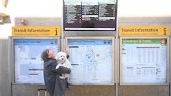
MTC and transit agency partners unveiled new test transit maps and signs in December 2024 in El Cerrito and in February 2025 in Santa Rosa. MTC notes that in late summer 2024, more than 150 on-site intercept surveys and 16 test journeys at El Cerrito and Santa Rosa were conducted to provide baseline data before the new test materials were installed. The agency says riders at two key bus transit locations — El Cerrito del Norte and the Santa Rosa Transit Mall — were asked six questions about the ease of transit use with existing signage. Riders were then asked the same questions after the test signs and maps were installed.
According to the MTC, the evaluation report found a significant benefit from the new maps and signage. Survey respondents reported a much easier time using transit after the test materials were in place than at the time of the baseline survey. MTC says the result was consistent for all six questions at both locations.
At El Cerrito del Norte, there was a 30 percentage point increase in the number of respondents who reported that the signs and maps made the overall experience of finding their way around the transit facility, understanding when a bus is arriving and understanding where a bus route goes “easy” or “very easy.” At the Santa Rosa Transit Mall, there was a 20 percentage point increase in survey respondents that said understanding when a bus is arriving and where a bus route goes were “easy” or “very easy."
Other key takeaways from the evaluation include:
- Customers use frequency information to plan trips, confirming its utility on signs and maps.
- Customers primarily look for the route number and destination on an approaching bus, affirming the prioritization of service information on bus stop signs.
- Agency logos are often proxies for information like fares, so the design of bus stop signs could be changed to accommodate larger logos and agency-specific customer service information.
- Customers could successfully associate a single train icon with most rail services.
MTC staff asked for public feedback on the test signs and maps via an online survey, which was offered in Spanish, Chinese and English, as well as through on-site intercept surveys. The project received 3,215 online survey responses and conducted 586 on-site intercept surveys. The evaluation also featured five online focus groups, including groups with Chinese and Spanish speakers and people with cognitive disabilities; 19 on-site individual test journeys, including Chinese and Spanish speakers and people with disabilities; two on-site accessibility working group tours; and three on-site tours for transit agency staff.
The agency notes public feedback on the new test signs and maps will help inform the next stages of the project, in which regional wayfinding design guidelines will be refined based on the comments that were received, and maps and wayfinding materials are expected to be installed at seven additional locations across the Bay Area starting in 2026.
According to the MTC, more than 90 percent of Bay Area residents polled by the agency in 2021 identified uniform and easy-to-use transit maps and signage as an important priority for improving the region’s transit network.