SFMTA debuts new international wayfinding standards
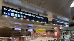
When the San Francisco Municipal Transportation Agency (SFMTA) reopened the Muni Metro subway May 15, 2021, customers noticed some changes at the Castro and Church stations: new overhead wayfinding signage more clearly identifying station exits and indicating where those exits lead and new cardinal (north, south, east, west) directions, which now indicate where trains are headed instead of the former “inbound/outbound” directions.
These stations–along with Powell Station, which will be updated soon–are part of the Metro Enhancement Project to improve the customer experience by providing better travel information, clearer wayfinding, cleaner stations and safety improvements. Treatments depend on the station, but enhancement elements include paint, lighting and accessibility improvements.
The project began with the Castro and Church Stations because those are easier to update than the shared BART stations. Powell is next in line in preparation for the opening of Central Subway. Looking forward, the aim is to improve all Muni Metro stations once additional funding can be identified.
Customers may also see cardinal directions on digital signs in other subway stations. This is a separate effort that is part of Muni Customer Service upgrades.
The need for change
When the Muni Metro subway system was built in the 1980s, all rail routes funneled downtown along Market Street, making the “inbound” (generally towards downtown) and “outbound” (generally away from downtown) directions easy to navigate. In 2006, when the T Third Muni Metro line combined with the K Ingleside, the new combined route traveled into downtown from two different directions, making Muni Metro’s traditional “inbound/outbound” orientations less effective.
In 2012, the Metropolitan Transportation Commission (MTC)–the transportation planning, financing and coordinating agency for the nine-county San Francisco Bay Area–adopted regional transit wayfinding guidelines and standards, and the SFMTA began working with other transportation agencies on a long-term plan for regional wayfinding integration and standardization, so that customers can navigate different systems in similar ways using route end destinations (last stops), station exit signage and accessibility information.
The development of Central Subway also pushed SFMTA to think critically about wayfinding and directional improvements to the Muni subway system, including the use of cardinal directions (north, south, east, west). Once the Central Subway is complete, the T Third Street route will realign to run north-south between two major job, population and commercial activity centers within the city, calling into question the concept of what is “inbound” and what is “outbound.”
For San Franciscans who are accustomed to Muni, wayfinding may not pose much of a challenge. But with the growth of Muni and other regional transit systems, it’s important to make navigating the Muni Metro subway more efficient and effective with proven best practices for wayfinding, route directions and accessibility.
Next steps
There are still many steps to fully update the Muni Metro subway that tie together with SFMTA’s new, soon-to-be-rolled-out Muni Customer Information System, long-term Metro map and permanent signage updates and more. The SFMTA also needs support to identify additional funding to continue implementing this project in all Metro stations.