Mapillary's Capture Projects built to give cities and mapmakers control over map data collection
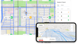
Mapillary, the street-level imagery platform that uses computer vision to fix the world’s maps, announced a new tool that allows cities and mapmakers to take control over their map data collection in order to build better maps at scale. Called Capture Projects, the tool consists of a combination of a web and a mobile app, named Mapillary for Drivers, that gives cities and mapmakers the ability to task and manage an unlimited number of drivers to capture street-level imagery at any given point, rapidly escalating how quickly map data can be generated just using cameras.
Jan Erik Solem, co-founder and CEO of Mapillary, says: “There’s always been a huge gap in being able to access map data at scale, for everyone from mapmakers and cities to transportation agencies and utility companies. Cities, for instance, normally pay contractors $4-6 per traffic sign when they need to do inventories of their street assets, simply because that's how expensive and time-consuming the old, manual approach is. Capture Projects slashes costs for both cities and contractors. It means that anyone can get an area systematically covered with imagery and map data, have all that data in their own workflows, and build better maps quicker as a direct result.”
The tool is announced just weeks after Mapillary put 186 million AI-generated map features on the global map, using nothing but images and computer vision. Derived from the 450 million street-level images that have been contributed to the Mapillary platform, Mapillary’s computer vision technology detects, positions, and places 43 different object classes onto the global map, ranging from utility poles and traffic signs to fire hydrants and CCTV cameras. Capture Projects means that anyone can speed up data collection in a geographical region of their choice to access computer vision-generated map data in that particular area.
Map data is becoming increasingly in demand as rapid advances in autonomous driving and urban development is escalating the need for a new way of mapping the world. Research shows that the global geospatial analytics market is set to surge by 357 percent between 2017 and 2027, growing from $38.6 billion to $174.6 billion as fresh map data is becoming increasingly important for industries ranging from transportation and automotive to GIS and maps.
Jan Erik Solem says Mapillary will continue building tools for connecting image capture with data demand on the Mapillary platform: “We’re the only player that processes street-level imagery from any camera and automatically generates map data that anyone can access. There is a huge demand for this and we’re working hard to make sure that cities and mapmakers will always be able to access the data they need, as fast as they need it.”
Capture Projects is available on Mapillary’s web platform, mapillary.com. The accompanying mobile app, Mapillary for Drivers, is currently available for iOS devices and is under development for Android devices.