How LiDAR is Making Roads Safer for Pedestrians and Cyclists
As populations have swelled and road traffic has increased in major metro areas throughout the world, keeping pedestrians and cyclists safe has become an increasingly important global public health concern. According to the Centers for Disease Control and Prevention, 3,700 people are fatally injured each day in traffic accidents around the world— a total of more than 1.35 million per year. More than half of these fatalities are pedestrians, motorcyclists and cyclists.
The most recent road safety report from the World Health Organization (WHO) notes that traffic injuries are now the leading cause of death globally for individuals between the ages of 5 and 29. The economic toll is massive: One study of 166 countries estimated that crash injuries will cost the world economy $1.8 trillion dollars (in 2010 USD) from 2015-2030.
With more people and vehicles sharing the roads, intelligent road management and smarter traffic policies are critical to saving lives and building safer cities. To meet this growing need, smart cities around the world have begun implementing LiDAR to monitor traffic and collect critical data to inform policies and infrastructure changes to protect pedestrian and cyclist safety.
LiDAR-Based Traffic Intelligence: How it Works
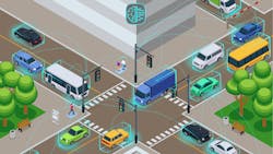
Light Detection and Ranging (LiDAR) is a time-of-flight sensing technology that pulses low-power, eye-safe lasers and measures the time it takes for the laser to complete a round trip between the sensor and a target. The resulting data is used to generate 3D point cloud images, providing advanced 3D perception and situational awareness about the scanned area. This data is then analyzed with computer perception software to extract valuable insights and power real-time, data-driven decision-making.
Installed at roads and intersections, LiDAR sensors monitor and autonomously collect traffic data, including how and when people and vehicles use this critical infrastructure. For example, the LiDAR sensors can identify and count pedestrians jaywalking, measure vehicle traffic volume, identify speeding vehicles and other hazards and much more.
This data can then be compared by time of day, day of the week, to identify patterns, predict safety hazards and ultimately inform transportation policies to improve pedestrian and cyclist safety. For example, data from LiDAR sensors is currently being used in cities to inform decisions and understand key metrics like:
- How many traffic lights should be installed, and where, to be most effective?
- How long should the pedestrian crossing time be?
- What hours and days of the week are experiencing the highest traffic and pose the highest safety risk?
- What are the most common factors that contribute to safety incidents? How can these factors be mitigated or eliminated?
In addition to driving policy and technology decisions, collected data can also be used in vehicle to everything (V2X) applications and delivered to both drivers and passengers to enable real-time decisions on the road.
Five Benefits of LiDAR for Traffic Monitoring
Because LiDAR provides the most accurate and granular 3D data of any other technology, city officials can get a complete and detailed picture of what is happening on the roads—and derive actionable insights that have never been possible with cameras and other sensing technologies. The following are five advantages of LiDAR for intelligent traffic monitoring.
1. Accurate Data in Any Environment
Accuracy is critical when lives are at stake. 3D LiDAR sensors provide greater than 95 percent detection accuracy and 24/7 reliability in all lighting and environmental conditions, including rain, snow, wind, dust, fog, bright sunlight and very low light. Because of this, LiDAR sensors are ideal for outdoor applications like monitoring traffic and cross walks.
2. Advanced 3D Perception
Some LiDAR sensors can capture hundreds of data points per second. The level of detail that LiDAR provides enables greater situational awareness than is possible with cameras or manual data collection. For example, with LiDAR, users can “see” all objects in a scanned area, identify what it is (i.e., pedestrian, cyclist or vehicle) and precisely measure their location and the speed at which they are traveling. This makes it possible to capture a complete picture of traffic scenarios and accurately determine how to prevent safety incidents.
3. Low Total Cost of Ownership
LiDAR sensors provide a low total cost of ownership compared to alternative technologies. With 360-degree coverage, only a few devices are required to monitor each traffic zone. With a few rugged devices to install and maintain, users can monitor traffic activity and collect critical data throughout the entire city for a comparably low cost.
4. Versatile Sensing Capabilities
LiDAR is a powerful and versatile technology that can handle the varied demands of traffic monitoring applications from identifying vehicles at high speeds on the highways to visualizing people hidden in blind zones.
5. Zero PII Risk
Any application that tracks and monitors people’s movement will inevitably raise privacy concerns. Fortunately, LiDAR doesn’t capture or store any personally identifiable information (PII), protecting privacy and eliminating PII risk.
Case Studies
3D LiDAR technology is already being used to protect pedestrian and cyclist safety around the world. For example, in 2012, South Korea held the second highest pedestrian death rate among OECD countries at 10.8 road fatalities per 100,000 people. Since then, the country has made considerable efforts to successfully lower these figures. After implementing these changes in 2017, South Korea recorded a lower number of pedestrian crashes than the preceding five years.
The Smart City Project - Busan, South Korea
Busan, South Korea, is one of several pilot cities in South Korea’s Smart City Project. The problem of road safety is a critical part of the country’s larger initiative to build people- and future-oriented cities by leveraging technologies and innovations that improve citizens’ safety and quality of life.
Prior to implementing LiDAR for traffic monitoring, Busan depended on manual data collection methods to understand traffic patterns and inform road policies. However, this process was prone to error and required staff in the field to collect the information, expending valuable time for less-than-optimal results. In addition, the city had considered AI-based CCTV technology; however, CCTV could not provide the data reliability the city needed to handle such a critical application as pedestrian safety. The data city officials were working with simply wasn’t accurate enough to make informed decisions that could save lives.
The Smart City Project ultimately chose a 3D LiDAR solution to continuously monitor roads and intersections in Busan. With more accurate data, Busan was able to improve the effectiveness of its transportation policies. LiDAR also automated the data collection, eliminating the need for manual, error-prone data collection methods.
Pedestrian Crossing in School Zones – Seoul, South Korea
School zones are a key area of concern in addressing the safety of a city’s youngest pedestrians. In the local governmental district of Nowon-Gu in Seoul, South Korea, a LiDAR-based solution provided the data city officials needed to understand and mitigate the contributing factors in school zone accidents.
The sensors gathered extensive data about each school crossing zone, including patterns in vehicle traffic, vehicle speeds and pedestrian behavior. For example, the solution can accurately detect a person standing in a blind spot (i.e., behind a parked car), a situation that frequently contributes to pedestrian-involved accidents. The data from this deployment formed the basis for new and more effective traffic policies and helped city officials decide on the best technology to keep pedestrians and drivers safe.
Conclusion
The need for safer roads remains a pressing public health concern and a focal point for smart cities. By leveraging emerging IoT technologies like LiDAR, cities can better understand how to protect their citizens from harm on the road.
----------
General Becker is vice president, market development and alliances, Quanergy Systems, Inc.
About the Author
Gerald Becker
Vice President of Market Development and Alliances, Quanergy Systems, Inc.
Gerald Becker leads the global alliance function at Quanergy, overseeing the identification, pursuit and development of strategic channel partnerships in the security, smart city and smart spaces markets.
Gerald earned an MBA in Information System from the University of Redlands and a B.S. in Technical Management from DeVry University. His career of over 17 years has been focused on leading brand initiatives, business development, and creating strategic alliances with technology and channel partners at technology, physical security, and IoT companies. Gerald most recently served as Sr. Director of Sales & Business Development at AI and computer vision applications company SAFR by RealNetworks, where he played a pivotal role in driving new global strategic alliances & technology partnerships to drive revenue growth.