King County Metro wins national award for improving data on sidewalks
To gather better information to improve pedestrian safety and transit access, King County Metro Transit joined its Access paratransit contractor, MV Transportation, to develop CommonPaths.
“We’ve been very car-centric,” said Matthew Weidner, King County Metro senior transit planner. “We have really good data on roads—what intersections look like, road conditions, places where you turn. But then when you think about the data everyday people have about sidewalks in their neighborhoods, there exists a huge amount of uncertainty.”
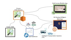
CommonPaths was created by leveraging research conducted at the University of Washington’s Taskar Center for Accessible Computing Technology. The system provides tools for agencies to collect and distribute high-fidelity pathway data in OpenSidewalks. Because the system uses an OpenStreetMaps collaborative framework, agencies can reap the benefits from contributions by other agencies, jurisdictions and the public to the OpenStreetMap platform. This helps reduce the effort to collect and maintain up-to-date information.
Weidner sees long-term possibilities for CommonPaths, including:
- Enabling pedestrians to receive personalized turn-by-turn GPS directions based upon their abilities with the same level of detail now available for car travel.
- Increasing equity by making it safer and easier for the disabled and others to access transit.
- Helping cities, towns, and other jurisdictions understand sidewalk conditions in their areas and precisely targeting investments to improve pedestrian accessibility.
- Allowing jurisdictions to collaborate on pedestrian and transit accessibility projects more easily and to clearly understand accessibility barriers for pedestrians.