L.A. Metro introduces new map to highlight transit options for 2028 Olympics
Ahead of the 2028 Olympic and Paralympic Games, the Los Angeles County Metropolitan Transportation Authority (L.A. Metro) has published a new geographic information system map to highlight the mobility improvements being made in the region for the games.
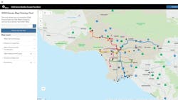
The agency notes that the map, which is still in beta, is a foundation for the work it’s doing to make these improvements. The agency says the map hosts what the metro system will look like in 2028, the location of the games venues and projects funded by the Reconnecting Communities and Neighborhoods grant awarded to L.A. Metro in March 2024.
The $139-million U.S. Department of Transportation grant will fund a bundle of improvements—new mobility hubs, first-last mile and bus priority projects—that the agency says aim to restore community connectivity by investing in high-quality multimodal transportation options.
As plans evolve and are finalized for various projects, they’ll be added to the map. The agency says the map is a way to visualize what the games transportation network will eventually look like, including transit projects, additional mobility hubs and bus shuttle routes to games venues.
The agency also says that sharing this information will also be helpful to local governments as they prepare to host events and inform residents how to easily get around during the Olympics and Paralympics.
From a technical standpoint, visitors to the map will be able to export the various layers to use for analysis. Nearly all L.A. Metro’s work ahead of the games will eventually be visualized on the map. Viewers can also provide feedback by clicking the contact us button at the top right of the page.