L.A. Metro launches new survey on accessing first three Purple (D Line) Extension stations
The Los Angeles County Metropolitan Transportation Authority (L.A. Metro) has launched a new survey to help inform the authority’s first/last mile plan to improve biking, walking and rolling access to and from the Purple (D Line) extension's first three stations.
In 2020, L.A. Metro completed the Purple Line Extension Sections 2 & 3 First/Last Mile Plan, which proposes street improvements in Beverly Hills, Westwood, West L.A. and Century City for the stations to be built in those areas. Now, the Section 1 first/last mile plan will address walking and biking connections for the preceding three stations in Mid-City Los Angeles and Beverly Hills: Wilshire/La Brea, Wilshire/Fairfax and Wilshire/La Cienega.
These station areas include a wide range of local and regional destinations in the Miracle Mile part of Wilshire Boulevard — LACMA, the future Academy Museum of Motion Pictures, Restaurant Row and access to the Grove and Farmer’s Market.
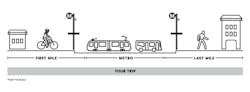
To get future D Line (Purple) riders to and from those destinations, the first/last mile plan will propose a suite of recommendations for the streets surrounding the three Section 1 stations, focusing on improvements that would make that leg of a trip more safe, comfortable or accessible for riders walking, biking or rolling.
These could include new sidewalks, more visible crosswalks, protected bike lanes and amenities like wayfinding and pedestrian lighting. Typically, first/last mile plans consider the half-mile radius around a station (about a 15-minute walk), but bike facilities could also be considered at a wider three-mile radius.
To make these recommendations, the plan needs to understand the current conditions around stations. This is where the survey comes in. Through the survey, users can drop pins on the map of the Section 1 station areas and mark any barriers or any needs they may see or experience today.
Know a street that would be a useful bike route to a station, or an intersection that takes too long to cross? Survey users can mark it on the map and add a note. Together, this input helps identify and prioritize the streets and improvement ideas to be addressed in the first/last mile plan.
The survey is available through April 2.