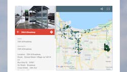
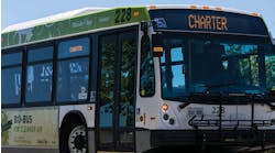
The Northwestern Indiana Regional Planning Commission (NIRPC) has launched a new online map that details the accessibility of every bus stop in Northwest Indiana.
For riders with disabilities, small challenges, like the size of a doorway or the softness of the gravel at a bus stop, can throw a wrench in their plans, and region urban planners are hoping this new map helps provide a more seamless transit experience.
Map details will allow region transit riders to navigate bus stops across all municipal and regional systems, find directions and determine the level of accessibility for riders with a disability—all before leaving on their trip.
The Northwest Indiana Transit Map can be found on NIRPC’s website.
NIRPC data analysts Peter Kimball and Kevin Polette traveled to each bus stop in Lake, Porter and La Porte counties—a total of 561 locations—during 2020 to assess many criteria for the inventory. The new tool provides Google Map directions to the location of a stop, photos, a physical description, accessibility details—like sidewalk measurements, curb types for wheelchair access and amenities like covered or heated structures—and the proximity to nearby bus routes across all three counties.
The Northwest Indiana Transit Map provides the following details.
Location information
- Bus stop location, nearby cross streets and the directional location on the intersection, such as the northwest or southeast corners or mid-block.
- The presence of restrooms within a short distance.
Physical environment
- Details about the landing area, such as length, width and material.
- The presence of a shelter and its size.
- Attributes such as trash cans, bike parking, seating or heat.
Accessibility details
- Ground conditions and material at the landing, such as grass, concrete, dirt or gravel.
- Whether the curb slope was cut was to ADA standards.
- The width of a shelter entryway.
- The interior space available in a shelter.
Connections to adjacent transportation
- A bus route or train station within two blocks of the bus stop.
- Connections like Park-and-Ride and transit facilities.
Informational tools
- Signage.
- Visible availability of maps, a hotline or timetables.
The Northwest Indiana Transit Map is the only map incorporating all transit systems, routes and bus stops within the region.
“The Northwest Indiana Transit Map is a place to view all bus stops from every transit agency in Northwest Indiana. We collected data on every stop, with pictures and the conditions of the bus stops,” said Polette, a technical assistant with NIRPC. “While collecting the data, we were also able to take public comments from the riders about the bus stops and routes.”
NIRPC staff received public feedback about the bus stops, which they passed on to transit operators. NIRPC’s urban planners hope the map will contribute to municipal and county transportation planning and will influence the decisions of municipal transit operators.
The team also included Allen Hammond, NIRPC’s coordinator for Americans with Disabilities Act compliance.


