Special Report: Passenger Information
Many transit agencies have been facing a decrease in ridership with more alternatives at their fingertips and one key to countering that is communication. Providing easily accessible information makes your system more attractive and improves rider satisfaction. In addition, information can better connect people to the community, can help in emergency situations and can sometimes generate revenue.
Mass Transit recently surveyed its audience to see where agencies were at for what information they provide, how they provide it and how they gather it, so you can get an idea of how you compare to your peers.
MaaS
To get people out of their cars and to keep people from requesting a ride from their phone, public transportation needs to be easily accessible. Mobility as a Service, MaaS, is the phrase we keep hearing and its key to making transit an easy choice.
MaaS integrates all of the riders needs into one interface. Using big data, a single interface can allow a rider to plan a trip, compare at the options, buy a ticket or pay a fare and track their trek in real time.
Brigadier General (Ret) John Michel, executive director of Skyworks Global and chairman of the board for DemandTrans Solutions recently wrote the following:
“With the emergence of ‘Mobility as a Service’ — or MaaS for short — the opportunity to organize the cluttered and confusing transportation marketplace is a rapidly unfolding possibility. The prospects of integrating a customer’s transportation needs with value-added solutions into a single interface is becoming a reality. How? Through the digitization of transportation made possible by mass access to smartphones, the proliferation of big data, and emergence of innovative and intelligent approaches to making the entire transport sector be more responsive to customers’ real-time needs and wants.
"In effect, MaaS is a catalyst to effectively erode, or better yet, outright eliminate the long-standing boundaries between varied transportation modes so consumers can now readily experience the same flexibility and convenience in public transit that they have become accustomed to experiencing in virtually every other part of their life. Finally, a new era of thought leadership and proactive effort is netting an ecosystem of transportation infrastructure, services, information, and payment capabilities that are transforming how people from all walks of life can efficiently and effortlessly move about our cities.”
More at MassTransitmag.com/12398032
[Graph: Real-Time Data]
[Graph: How You Provide Real-Time Data]
Terminology
GTFS: General Transit Feed Specification – A standardized, digitized format for public transportation schedules and associated geographic information. GTFS feeds let public transit agencies publish their transit data and developers write applications that consume that data in an interoperable way.
API: Application Programming Interface – An interface that allows software programs to interact with each other.
Getting Information to the Rider
The Maryland Transit Administration was a designated recipient of Section 5316, Job Access and Reverse Commute (JARC) program funds and worked in partnership with the Central Maryland Regional Transit (CMRT) to build the Transportation Resource Information Point (TRIP) to help people use transportation alternatives throughout Central Maryland.
The TRIP team at CMRT took advantage of the National Rural Transit Assistance Program’s GTFS Builder to gather transit feed data from around the state. The RTAP GTFS builder includes Excel spreadsheet-based data management tools and instructional videos to help any size agency work with GTFS feeds.
For more on TRIP in Maryland, Connecting Beyond Boundaries with GTFS Digitized Data MassTransitmag.com/12308740
For RTAP’s GTFS (General Transit Feed Specification) Builder nationalrtap.org/Web-Apps/GTFS-Builder
Ensuring Equity
Reliance on smartphones for online access is common among several demographics. According to the Pew Research Center, approximately three in 10 adults with household incomes below $30,000 a year don’t own a smartphone and nearly half don’t have home broadband services or a traditional computer.
According to the U.S. Census Bureau, there are more than 56 million people in the United States living with a disability. They are about three times as likely as those without a disability to say they never go online, according to a 2016 Pew Research Center survey.
[Graph: Mobile Phone Ownership]
[Graph: Smartphone Dependence by Age]
[Graph: Smartphone Dependence by Race]
[Graph: Smartphone Dependence by Income]
Signage Delivers Flexibility
Doug Anderson, director of ITS at Los Angeles County Metropolitan Transportation Authority, wrote moving from a paper world to a new digital experience onboard public transit may seem to be a high maintenance, overwhelming endeavor, but looking at the stark difference between the passenger experience, the digital experience is transformational.
[[[sidebar]]]
Enhancing the Transit Customer Experience with Digital Signage
[stock photo of someone on a bus on his or her phone or headshot, image: 12389612]
The digital experience can provide dynamic updates to information needed by the passenger to reduce anxiety thus allowing the passenger to relax and refocus their attention on other concerns. Advertising becomes more effective and passengers can actually make use of the time in transit to accomplish other tasks. The potential to arrive at their destination with less stress with a jump on their daily tasks completely changes the start of each new day. The likelihood that the passenger will repeat their use of transit while also spreading positive word-of-mouth regarding their experience is powerful. The potential for generating additional advertising revenue increases as digital display technology allows for more ads for a given footprint onboard the vehicle.
The potential for even greater use of targeted display content based on geographic proximity is almost unlimited. For example, the language could change based on the demographics of the neighborhood being passed. Special service alerts for abducted children could also be targeted in the areas they were last seen. Information for connecting transit services could be displayed with predicted connection times.
The future for digital display technology — especially when combined with onboard GPS trackers and cellular connectivity — is bright (pun intended). The potential to convey real-time travel information to passengers to assist and support them during their journey can be transformational.
[[[end sidebar]]]
[Graph or Callout: Digital Signage Implementation in the Next 3 Years]
[Graph: Information provided via digital signage]
Terminology
LCD: Liquid Crystal Display - A display where thin film transistors (TFTs) on the surface apply an electric current to crystals of liquid. The current polarizes the crystals which makes them twist, blocking light and emitting different shades of light.
LED: Light Emitting Diode - In a diode, electrical current is only able to pass through in one direction. When electricity is applied to the diodes, light is emitted. The technology is similar to that of a light bulb.
OLED: Organic Light Emitting Diodes – A flat light emitting technology made by placing a series of organic thin films between two conductors. When electrical current is applied, a bright light is emitted.
LCD offers bright, high-resolution images. They have a thin design and are lightweight. They require a light source to illuminate the pixels. They use cold cathode fluorescent lamps (CCFL) to illuminate the display. Some of the drawbacks are the size limited the minimum depth of the panel, they require a lot of power and have a limited life expectancy.
LEDs solved those issues by using a light emitting diode as the light source to illuminate the pixels. The panel could be thinner, use less power and have a longer lifespan. For outdoor use, they can have a higher brightness and be built to withstand the weather extremes but also come with an increased cost.
OLED displays eliminate the need for a separate backlight as each pixel emits its own light. They can come in a thin design, allowing more flexibility for the display area and they offer a much higher contrast. When an OLED screen goes black, its pixels actually produce no light.
Overcoming Content Challenges
[Graph: How is Content Created]
[Image: 12369750]
Although often relegated to the back seat, the process of content creation drives the success of a digital signage program. It is therefore essential to develop a mental map of each component stage, from strategizing and budgeting, through development and optimization, and to address the unique requirements and challenges of each one. With a clear plan in place, potential stall-outs are easily avoided, and obstacles, overcome.
For 10 obstacles to content creation and how to tackle them: MassTransitmag.com/12369749
[Image: WMATA]
Safety and Emergency Communications
The Washington Metropolitan Area Transit Authority deployed a digital signage project to inform riders about track work and other travel issues before passing through the fare gates. Challenges they needed to consider included the environment – temperature extremes, snow, dirt and dust, direct sunlight and vandalism; scope – unit control, full station control, full transit system control; ease of maintenance; and cost of downtime.
In late 2012, Metro mounted 110 Peerless-AV Xtreme Outdoor Displays on station manager kiosks inside and outside Metro stations with digital media players inside the booths feeding content to each display.
The real-time capabilities of digital signage makes it ideal for getting emergency notification messages out instantly.
A Rich Media Technologies study showed digital signage to be 63 percent more attention-getting than static signs, so utilizing it during non-emergency times for public service safety announcements means it's grabbing your riders' attention.
For tips on display location, budget and content control for digital signage for public safety, visit MassTransitmag.com/12303988
A New Dimension in Passenger Information
Big data, machine learning and virtual and augmented reality are taking passenger information to the next level. Advanced technology gives the rider the information they want, where they are and when they want it.
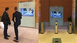
Image: 12375309
Intersection’s interactive kiosk at Southeastern Pennsylvania Transportation Authority's Suburban Station. By generating data that helps transit agencies understand the real-time status of their system, they can respond to customer needs. Kiosks can combine interactive wayfinding, service changes, and real-time arrivals customized to the station or platform where the kiosk is located.
Terminology
VR: Virtual Reality – A computer-generated scenario that simulates a realistic experience.
AR: Augmented Reality – A live view of a physical, real-world environment, augmented by computer-generated perceptual information.
SSI: Screen-Smart Device Interaction – A large screen flow of information or content can be affected by a small screen, such as a cellphone.
Virtual Reality in Public Transportation
Image: 12325473
Regional Transportation Commission of Washoe County Project Manager Jeff Wilbrecht, P.E., demonstrates the virtual reality “walk-through” of the 4th/Prater corridor, which they used at the Transportation Innovation Day at the State Legislature. A virtual reality tour along a future transit line gives people a first-hand view of what the project will look like. Devin Crowley, graphic designer – Transportation, at Wood Rodgers, went through Google Street View and modeled every building along the corridor to help people visualize the project’s impact on the community.
Augmented Reality in Public Transportation
Image: 12386571
DEPARTURESlive from INIT is an app that shows real-time departure information for individual stops, making it easier to find the nearest stop through augmented reality. The transit rider can track journey progress, see connection information and see the real-time departure information for the stops they’re at.