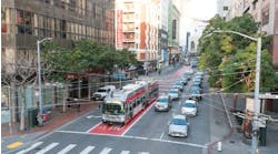
For passengers in the realm of bus, subway and light rail vehicle (LRV) commuting, waiting longer than necessary for your bus or train is always an exercise in frustration and anticipation of when your delayed vehicle will arrive at your stop. In the budding years of the 21st century public transit, that anticipation has been addressed by digital signage and sophisticated predictive software that deals with vehicle prediction arrival times in passenger waiting areas, and on transit vehicles' onboard destination arrival signage.
In modernizing passenger vehicle arrival and destination alert systems, public transit's bag of tools include LCD and LED displays, the Internet, fiber optics, wireless, GPS triangulation and predictive arrival software, all designed to put your passengers commuting minds at ease. With rising gas prices and other complexities (escalating car insurance rates, car pool lanes with weird regulations), of driving cars, public transit is becoming more and more of an urban necessity for people commuting to work, to recreation and dealing with their daily errands.
Public transit digital signage has evolved from a commuter luxury to a definitive necessity; and it is estimated that within the United States up to 95 percent of transit agencies now incorporate some kind of electronic sign system on their bus/rail fleets. Digital transit signage systems are now a major customer service feature to create assurance and confidence that the transit system operates as promised and just about "guarantees," its real-time information (barring transit accidents or intense weather conditions) that the transit will arrive when it says it will. When it can't, it immediately alerts passengers to an alternate arrival schedule.
In any passenger public transit commute scenario, the big transit operations concern is finding up-to-the-minute ways of communicating with passengers to keep them informed of their transit vehicles real-time status and changes to that status as they come up. These messages include estimated arrival times of all trains stopping at that platform, arriving train alerts, date and time, PSAs, platform or train operation out of service alerts or alternate service alerts, etc. Transit agencies are resolving these communication concerns with elaborate electronic displays found in ticket booths, on and inside buses, on passenger waiting areas within bus shelters, overhead at rail platforms, and on-board trains, when possible. And furthermore with various personal computing connectivity, on home computers and smart phones as well.
In reviewing current public transit passenger communication systems, several companies involved in providing these display systems discussed their hardware/software product solutions and service integration with their client transit agencies.
Twinvision
One such company is TwinVision (Durham, N.C.) which manufacturers what it refers to as "electronic information display systems" for public/private transit agencies. "TwinVision provides digital signage," says Larry Hagemann, chief technology officer, "on buses (most of client base) and trains (and LRVs), for both domestic and international transit agencies. Since its founding in 1996, TwinVision has provided digital vehicle signage to various mass transit agencies in all 50 states and about 50 countries around the world (through its European sister company, Mobitec AB)."
TwinVision's use of LED transit displays for vehicle passenger information has significantly improved bus and rail signage operational efficiencies, maintainability and passenger communications. In 2000, TwinVision introduced the all-LED sign display as a bus sign product. Color has always been an important component of TwinVision digital signage, used early on as a display indicator to expand transit route identification. "In 2003, we transferred from a monochromatic (amber) display to using full color displays as vehicle route identifiers," Hagemann states. "We've also increased the sign size to allow for a multi-line display on the front of the bus to give better and more specific information about the bus's destination.”
"As a digital bus sign supplier, we are constantly seeking out areas of digital sign development/enhancement and sustainability,” says Hagemann. “In the last 24 months, we've seen continual LED improvements both in its technological efficiencies and as a customer service offering for improving the passenger's transit experience.” Further offerings include:
- Wireless transfer of vehicle route information now speeds up vehicle transit data changes to the buses in acquiring updated routing and passenger alert messages.
- Vehicle signage now has remote diagnostic management capabilities which allows independent monitoring of the local bus fleet's on-board signage.
- Power consumption of LED displays is more efficient as less energy is needed to power the same intensity on the signs.
- White LEDs have become a preferred color for LED bus displays. Its price point has become more affordable and its illumination is very bright for spotting buses from a longer distance as they approach their bus stops.
As for passenger information content, TwinVision's sister company, Digital Recorders Inc. (Durham, N.C.), also offers a host of transit information services including a bus automatic vehicle tracking (AVL) system and a real time vehicle arrival prediction information system. Passenger information is presented as signage alerts, as voice announcements and is also accessible through home computers and smart phone connectivity. "Ultimately it's about how much information we can practically give the passengers that helps make their travels easier and more efficient, and provides them with an excellent riding experience,” Hagemann states.
TransitVUE Transit Communications Systems
In another effort to improve transit passenger commuting experiences, TransitVUE Communications Systems (Chino, Calif.), has created several passenger information communication formats for the mass transit and rail public transit systems. As a developer and a manufacturer, the company has designed the TransitVUE Passenger Information System (TPIS) as an overhead platform and mezzanine level digital display media system. "This system has the ability to display rail and bus real-time transit vehicle scheduling information," says TransitVUE President Ken Rivera, "and integrate that data onto TransitVUE displays throughout a transit client's bus/rail network."
"Currently, the TPIS combines data, text and graphics and uses scheduled and real-time GPS data to track (live) a train's location and be able to distribute that within the TPIS network and also show it on a Google map," Rivera notes. "This allows TPIS to inform passengers of their train's location within that subway or light rail system, and tell them how soon their train will arrive."
TPIS communications is represented by its Vantage Server Software (VSS), which operates in a client-server configuration. Here the content server is composed of various intelligent system displays, redundant database servers and networking equipment all configured into the transit agency's rail or bus routes. The server software is platform independent and runs on virtually any operating system from Windows to Linux. Similarly, VSS can function with a variety of relational databases including Microsoft SQL, MySQL and Oracle. Each TPIS set up is interconnected depending on station locales with fiber optic, wireless, LAN, WAN or cellular networks.
The main display workhorse for TPIS is a “ruggedized” LCD screen (available in various sizes typically ranging from 30 to 57 inches) which is enclosed within a protective aluminum cabinet with a transparent acrylic front. To ensure uncorrupted data transmissions, all TransitVUE connections are coupled with fiber optic links both from display to display and from all separate platforms back to the main transit control center. In most cases, the TransitVUE LCD unit is located overhead on a LRV or subway platform, as a ceiling display presenting a continuous stream of passenger alerts, scheduling announcements and transit updates.
As passengers pass through a typical transit station, there are two major locales for TPIS installations; the mezzanine where the platform entrance is located and the station platform. In each situation TransitVUE has a localized TPIS display set-up to keep passengers informed of the train's system status.
Mezzanine Transit Alerts
The first component is mezzanine-based and is represented by TPIS monitors, which present general information, such as the location of the ticket booths and ticket prices. These mezzanine monitors can be seen hanging from the ceiling or mounted onto walls in visible areas of the mezzanine common space.
Ticket and Travel Guide Kiosk
In development as a further extension of TPIS is TransitVUE Interactive Passenger Information Kiosk. The IPIK is essentially a touch-screen display attached next to a ticket vending machine that provides passengers background information on transit ticket costs, how to purchase those tickets and vehicle transfer info (if related that destination) as well.
The kiosk is also able to recommend travel routes if a passenger types in both their start point and their end point. Further, the kiosk acts as a 'travel guide' by offering point of interest travel information about possible sightseeing destinations along that route. Finally the kiosk can offer hard copy information, either as maps with their travel info printed on the map layout or text info relating to travel recommendations from that passenger's queries.
"Now Arriving On Track Three"
From the mezzanine, passengers move to the station platform where overhead TPIS displays are strategically placed above the length of the platform for ease of viewing. The number of TPIS displays at any station depends on the size and location of the station. As Rivera notes, "in a typical station configuration, we might have as many as 16 overhead LCD screens (eight per side). TPIS utilizes both LCD displays and horizontal LED tickers for presenting passenger alert transit messages. Indoors and underground we rely on overhead LCD monitors, but outdoors, depending on how TPIS is configured, we might use both LCD screens, which are sunlight readable high brightness monitors, and LED tickers working in tandem."
TPIS On-Board
TransitVUE has also extended TPIS as an on-board LRV display setup as well. This component of TPIS is composed of an LCD display (at least two monitors per train car) presenting passengers with on board information alerts on station location, arrival/departure status, safety messages and places of interest information for each station. Information updates to TPIS are added while the train is held at the station and passed along from platform infrastructure to the train for immediate display to on-board passengers. TransitVUE Communications Systems is in the process of developing a TPIS on-board demo system for LACMTA for 2012.
TPIS Push-to-Listen
Another addition to TransitVUE TPIS line of applications is TPIS “Push-to-Listen” system for visually impaired people. Originally, the idea to develop this product came from the needs of the visually impaired people who use the LA Metro rail and bus system by expanding the capabilities of the current TransitVUE TPIS. TransitVUE TPIS “Push-to-Listen” is an ADA-compliant system that provides the same train arrival, departure and service announcements as displayed on the LCD monitors and LED message boards of wayside TPIS customer messaging systems. Visually impaired passengers would be able to access information by pressing one of two buttons located on “Push-to-Listen” boxes installed at the station entrances near ticketing machines as well as at the exits. The instructions on the box are written in raised Braille in accordance with ADA standards. The launch of TPIS “Push-to-Listen” went live in January 2012 on the Pasadena Gold Line Del Mar Station.
LA Metro Gains Digital Information System
The first TPIS network was installed in 2007 within the Los Angeles Metro Agency (LACMTA), in which 350 LCD ruggedized (with the 46-inch displays) indoor screens were placed throughout LA Metro's Red Line with TPIS installations in all of its 14 stations. Overall TPIS is agnostic as to where it is installed and it works equally well on bus routes as Rivera notes."On the LA Metro Purple line, two rail stations are connecting points for buses and our passenger alerts at both stations provide appropriate bus arrival/departure alerts as needed." In 2011, TransitVUE installed 64 LCD monitors and 24 single line LED message boards on the 21 stations of the LA Metro Gold Line.
NextBus
NextBus Inc. is both a company (Emeryville, Calif. - since 1996) and the name of its major software solution, which is a real-time passenger information system that is offered to municipal, university and corporate transit agencies throughout the United States and Canada. The NextBus RTPIS program is owned and operated by NextBus and utilized by such diverse transit agencies as SF MUNI in San Francisco, the Massachusetts Institute of Technology and LA Metro in Los Angeles. Each NextBus agency version is dedicated to that transit agency's vehicle fleet and their passenger waiting areas with appropriate digital signage to display that city's RTPIS alerts.
The NextBus RTPIS program is a predictive analysis software package that presents via electronic signage when the next bus or train will arrive at a given passenger waiting spot. The system was explained by Russell Chun, a NextBus project manager, "It starts with a bus or LRV in motion which is physically tracked through its transit route. Each bus connected to our RTPIS network has a GPS transmitter whose signal is collected by a NextBus GPS receiver which then merges the bus's real time location with its per-stop vehicle arrival prediction. Then the RTPIS program compares the vehicle's location to its next intended stop and then estimates the vehicle's minutes to arrival at that stop.
"We know which transit vehicle is sending information, where it is on its route and what its next 'official' stop is. That becomes a triangulation that allows us to predict the vehicle's intended time of arrival to its next stop. As to how effective RTPIS is," Chun says, "it all depends on what's happening in the real world as there are some variables we can't account for such as traffic jams, accidents, bad weather, etc.
"The result is a series of ongoing displays or mini-reports that passengers are able to view and are updated every minute or so. These reports appear on LCD displays or LED electronic message boards," says Chun, "which are installed on overhead displays on train and subway platforms or on bus shelters for passengers waiting for approaching buses."
Next Bus also conforms to current ADA regulations for the visually impaired with the operation of an equivalent audio information system known as "Push To Talk," where you push a button within the vehicle stopping area and the audio system enunciates what you also see on the sign."
Passengers who are trying to make travel plans before they leave their home can access NextBus transit alerts on their home computer to get a 'next-up' predicted arrival alert on their intended bus or rail route. Likewise if they're already on the road, they can also use their smart phones to access NextBus.com for prediction information.
San Francisco Muni
One NextBus client, the San Francisco Municipal Transit Agency (MUNI) employs more than 830 NextBus digital signs that are deployed throughout its MUNI transit system. All of MUNI's buses, LRV platforms and many of its bus shelters have an LED display that transmits route messages and the next two estimated vehicle arrival times for the stop. Also on the SF MUNI LRV platforms are ruggedized large LCD ceiling displays which show off a complete San Francisco LRV track map with real-time indicators of where trains are in their approach to each platform stop as well as arrival predictions. Within the LRV train stations, as MUNI passengers approach the ticket booth, there are RTPIS displays facing outwards that provide up-to-the-minute LRV updates even before they enter into the MUNI system.
Daktronics
From its corporate headquarters in Brookings, S.D., Daktronics provides LED sign systems for a wide variety of applications throughout the world, including products engineered specifically for the mass transit market. The company’s mass transit customers typically apply these Daktronics message centers to inform people waiting on rail station platforms. In appropriate bus terminal locations, Daktronics can also deploy large arrival/departure scheduling displays. In bus transit, Daktronics offers passenger alert signage as well as scheduling displays which play an important role in bus shelters and terminals.
For these applications, Daktronics recommends its Galaxy series message centers, which are offered in sizes that show single or multi-line text in an 8 or 12 mm pitches. These sizes facilitate ADA-required character sizes from 2 to 9.6 inches tall. Transit agencies have the choice of utilizing either amber-only or tri-color (red, green and amber) displays which organize affirmative (green), negative (red) and neutral (amber) information. Polycarbonate faces and NEMA 4X enclosures protect these displays from brake dust, rain, snow and ice.
Daktronics has served the mass transit community for decades and has provided LED signage for any number of transit agencies including MTA Metro North (New York), Akron Metro (Akron, Ohio), Tri Met (Portland, Ore.) and Sandag (San Diego).
Recently, the historic Washington Union Station awarded a project to Daktronics in which the company replaced an antiquated scheduling display with a tri-color Daktronics Galaxy message center which serves as the centerpiece to the station’s grand hall in Washington, D.C.
Journeys and Destinations
Transit passenger information systems may be a specialized sign system, but they follow the same development rules of digital signage as much as any retail or wayfinding sign system. Ultimately transit digital signage (like retail) is all about content, whose transit messages (like retail) must be relevant, short and informative to the needs of its audience.
Transit information content occupies two sides of a coin. On one side, brevity rules, dealing with the where and the when of a vehicle arrival, and when it's delayed, the why. On the flip side of the coin is scads of information on the how - the rules of transit and ticket purchase, when to use transfers, and even more, as a sophisticated transit system could evolve from just information and a transit route indicator to incorporating a greater depth of background on destinations along the route as discussed by TransitVUE's forthcoming Transit Kiosk Information System.
Inevitably, transit agencies are developing transit signage as elaborate way-finding systems to help passengers move from point A to point B in the best way possible. Given the arrival of digital signage and its transit content on route and destination information services, one could say that the journey to the destination will be as interesting as the destination itself.
Louis M. Brill is a journalist and a consultant for high-tech media communications and can be reached at (415) 664-0694 or at [email protected].